American Battlefield Trust, Cowpens National Battlefield launch animated map tracing the dynamic story of the Revolutionary War’s Southern Campaign
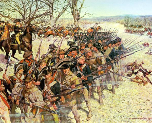
Gaffney, S.C. – “We fight, get beat, rise, and fight again.” The words of patriot General Nathanael Greene characterize the tenacious spirit of the patriots who fought the Revolutionary War’s Southern Campaign, a critical period brought to life like never before in the new animated map created by the American Battlefield Trust and Cowpens National Battlefield. With riveting storytelling and striking visuals, the new animated map was produced by the award-winning Wide Awake Films and intended for exhibition at Cowpens National Battlefield visitor center, as well as other National Park Service sites affiliated with the campaign. Although building interiors remain closed, visitors to Cowpens and Ninety Six National Historic Site have begun enjoying the didactic resource al fresco, and the Trust has also now made it available to broader audiences through its YouTube channel.
“Viewers of this exceptional production will benefit from the insight delivered through its sophisticated examination of the Southern Campaign,” said Trust president David Duncan. “The Trust is pleased to partner with the Southern Campaign of the American Revolution Parks Group to highlight this important piece of history and share our enthusiasm for history education with many generations.”
Diana Bramble, Acting Superintendent for the Southern Campaign of the American Revolution Parks Group concurred, adding, “The Southern Campaign Animated Map is a wonderful way to orient visitors to our park and provide context regarding its profound significance in the Revolutionary War. Both the National Park Service and the Trust are committed to preserving history and providing compelling connections for visitors to better understand the importance of the southern campaign battles. The National Park Service is proud to have collaborated with the Trust on this project."
The nearly 15-minute production is the result of meticulous planning and allows viewers to see the full picture of this significant and multifaceted campaign. The mesmerizing story is told through a combination of dramatic narration, historic images, motion graphics, battle reenactment footage, movement on still photography, and music befitting the epic story at play.
“This animated map posed an amazing opportunity to not only bring attention to this decisive campaign of the Revolutionary War, but also to reenergize history with the vibrant visuals and audio that our team is accustomed to delivering,” said Shane Seley, producer and director — as well as founder — at Wide Awake Films, a longtime Trust partner on video and multimedia projects.
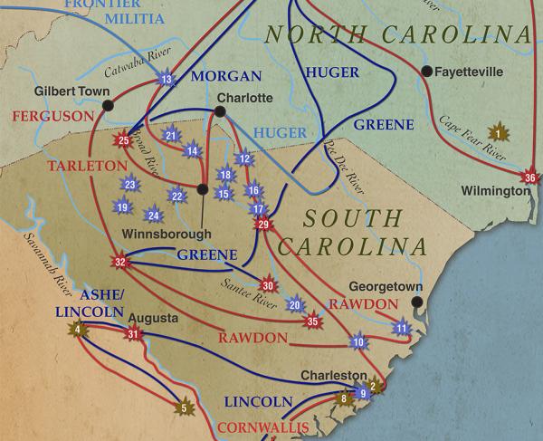
The Southern Campaign Animated Map transports viewers back as far to 1775 as it endeavors to expose the extent to which the war was fought on southern soil. Demonstrating the early action in the region, the map first points to Fort Charlotte, as it was seized by the patriots in July 1775. Victory was fleeting, in part, because of the immense political division that existed in South Carolina’s backcountry. Colonists were split between those who remained loyal to the British Crown and those supporting independence, yielding backcountry battles that pitted brother against brother. By late 1780, the Southern Campaigns embodied Greene’s famous statement of tenacity: even as the British gained tactical victories, the Americans gained a strategic upper-hand by dealing heavy blows through troop attrition. Eventually, beset by setbacks, Cornwallis opted to open a new campaign in Virginia — one that ended in surrender at Yorktown.

Supplying a story full of twists and turns, and illustrative of the Revolution’s relentless spirit, the Southern Campaign Animated Map has received great applause since its recent premiere as part of the current programs offered at Cowpens National Battlefield and Ninety Six National Historic Site, and it will eventually debut at Kings Mountain National Military Park in Blacksburg, S.C. All three sites are affiliated with the initial phase of the Liberty Trail, a joint effort of the American Battlefield Trust and the South Carolina Battleground Preservation Trust, with the support of the National Park Service. The Liberty Trail will ultimately link more than 70 sites associated with the Southern Campaign, preserving some 2,500 acres and creating a new driving tour that functions as a one-of-a-kind educational multimedia and heritage tourism resource. Learn more at www.TheLibertyTrail.org.
The Southern Campaign Animated Map joins a broader series of titles created by the Trust, which have been viewed millions of times by users around the world. Previous editions in this format include comprehensive tellings of the entire Revolutionary War and Civil War, as well as 10 battle or campaign-level productions. All of the Trust’s animated maps are available at www.youtube.com/americanbattlefieldtrust.
###
About the American Battlefield Trust
The American Battlefield Trust is dedicated to preserving America’s hallowed battlegrounds and educating the public about what happened there and why it matters today. The nonprofit, nonpartisan organization has protected more than 53,000 acres associated with the Revolutionary War, War of 1812, and Civil War. Learn more at www.battlefields.org.
About Cowpens National Battlefield
Cowpens National Battlefield is a Revolutionary War battle site that commemorates the January 1781 victory of Brigadier General Daniel Morgan over his dreaded foe, Lieutenant Colonel Banastre Tarleton, in the cause for American Independence. It was an important link in a chain of events that ultimately led to the defeat and surrender of the British commander Lord Earl Cornwallis at Yorktown, Virginia, in October 1781. The battlefield is a unit of the National Park System, a bureau of the United States Department of the Interior. Learn more at www.nps.gov/cowp.